Monday 25 March 2013

Nearly done.

Hi everyone. Sending this from the small coastal town of Riverton on the south coast of New Zealand.
Just 60 km's (Approx 37 miles) to go and just 2 more days of walking and we will be
standing at Bluff. The southern terminus of the Te Araroa Trail.

Within a few days of arriving back with family, I will post 2 full blogs.
One of the gear we used and one to finalize the entire journey with some pics.

The weather forecast for the next few days is looking great.
The excitement of finishing is growing with every step, as is the anticipation
of completing an incredible journey.

See you in a few days.


Along the south coast heading toward Riverton


Sunset on the Riverton Harbor

Friday 22 March 2013

The Southern Alps

The Southern Alps of New Zealand are the longest and highest mountain range in the country.  They consist of fairly new ranges in comparison to other ranges worldwide, and extend most of the length of the South Island.  As you have seen in some of the pictures I have already posted, you will find ice-blue glaciers, ancient forests, volcanic lakes, greenstone rivers and wide valleys...all which make up an amazing area of natural beauty! Check out two of my favorite areas below:

                   Mount Cook


Aoraki / Mount Cook is the highest mountain in New Zealand, reaching 3,754 metres (12,316 ft). It  consists of three summits, with the high peak spanning a mile long.   It lies in the Southern Alps, which is the mountain range that runs the length of the South Island.  Mount Cook National Park, was established in 1953, and contains more than 140 peaks standing over 2,000 metres (6,600 ft) and 72 named glaciers, which cover 40 percent of the park's 700 square kilometres (170,000 acres). It is a very popular distination for climbers and hikers, as the park offers a good challenge...but, you can enjoy it as a regular tourist with more than fantastics views and easy day walks, as Mount Cook Village is easy to get around.


                           The Remarkables


The Remarkables, located in Otago, are clearly visible from the nearby town of Queenstown.   Located on the southeastern shore of Lake Wakatipu, the range lives up to its name by rising sharply to create an impressive backdrop for the waters.  The area offers a wide range of activities to choose from in all seasons!

We are now just days away from Bluff, the official end of the Te Araroa Trail!  What an incredible journey it has been.  I'm very excited to get back home to Melody and family...and of course, the trail food will be happily tucked away for while!

I will be posting another blog once we have finished...until then...enjoy!

Friday 15 March 2013

Lake Tekapo to Lake Wanaka (Lake district)

This summer has turned out to be a dandy for tramping...but certainly not for farming.
It has been one of the hottest and extremely dry seasons in a long time...however, it's been great for our hiking and the photos we have captured.

Lake Pukaki with Mount Cook in background.


Gary and Madeline invited us into their motor home
for cold refreshments. Check out the name on the bus...
We didn't smell that bad on this day.

Lake Ohau

Taking a mid day nap high in the moutain's and dreaming
of Bluff...only about 450 km's...just a stones throw away...maybe not...

Big river valleys...they look like they go on forever don't they...almost do!

Steep...open.. and above tree line.

Overlooking Lake Hawea

Met these sky divers on the way down to Lake Hawea.
Malachi (middle) invited us to his home for a shower
and a cold beer. Malachi is a professional sky diver in Wanaka.
Salt of the earth friendly guy.

Heading around Lake Hawea.

On the shores of picturesque Lake Wanaka.

Becks and Chris (owners of Wanakayaks) hosted us at their place.
Just awesome friendly down to earth couple!


I haven't weighed myself in a while...
Last time, I was down to 141 lbs. (starting weight was 152 lbs)
Surely I can't loose any more...

Time will tell....

Question:  Do you know why the lakes and rivers can be so bright and vivid in color?

Lake Wanaka to Queenstown

Another beautiful but strenuous section of trail, through the Matitapu Range.

Morning sun becons us on...

What goes up, must come down!

4 km's through the stream...soggy feet!

Wow! look at this crystal clear water and how it reflects the colorful rocks.
"There's gold in them hills!"


Just north of Queenstown is the Millbrook Resort.

Queenstown is know as the "Adrenaline Capital" of the world!
For us, it represents 2,670 km's done and approx 2 weeks to go!

I will try and post at least once more before we make it to Bluff.
The excitement is building and becoming more palatable each day.
Too many thoughts going through my head right now...

Thursday 7 March 2013

Arturs Pass to Lake Tekapo

The view looking back towards Arthur's Pass.


Long stretches

Big open valleys

"Shadow and Country Mouse" from Bishop, CA...they hiked the Appalachian Trail
in 2011, and are the first North bounders on the Te Araroa.

Hamilton Hut


Huge scree field

Crossing the Rangatata River. The river valley was over 5 miles wide and
took us two and a half hours to cross!

View of Lake Tekapo from Stag Saddle


First glimpse of Mount Cook in the back ground...Fantastic!!!

Above Lake Tekapo

Swanny putting on a great BBQ for us in Tekapo...Great host.
Sarn's friend from the Police Search and Rescue.

Sooo relaxing... in the hot pools of  Tekapo Springs.
If you are ever in this area, it is a must!
The only reason I left? - - - - - - - I was...can you guess...hungry!

Next big town is Queenstown.  About 200 km's from here.
The adrenalin capital of the world.

See you there!

Monday 4 March 2013

Lewis Pass to Arthurs Pass

After soaking for 2 hours in the mineral pools at Hanmer Springs, Dad and Ben took us back to the trail head. Awesome to have them come down and join us for a day.


Dad, 81 years young, still has the spirit. He was ready to join us if it hadn't been for the ferry they had to catch back to Wellington.


One of the longest swing bridges we crossed.
These bridges are needed in the steep mountain gorges of New Zealand.


Sarn taking advantage of a natural hot spring deep in the mountains.


Huts, huts and more huts...each with their own character and charm.
This is an old hunters hut. I will be featuring some more in the future.


One of the many boulder strewn stream beds that are part of the trail.
You literally make your way (follow your nose) up stream until you see another
orange marker. Can you spot Sarn some where in this photo?


Crossing over Goat Pass and into Mingha Valley towards Arthur's Pass.


This is what happens when you loose a bet...Press-ups
in Arthurs pass.
...one...two...three...ten...


Here, we see a Kea (Mountain Parrot) trying to eat this sun umbrella.
Kea's are known for their mischievousness.


Question:  What is the national sport of New Zealand and where do we rank world wide?


Day off with Family in Christchurch

Carol, Sarn's mum, flew in from Sydney, Australia to spend a day with us.
She picked us up in Arthur's Pass and took us to her sister Kaye's house in
the Christchurch area. Some much needed R and R and plenty of food!

Carol making a spectacular omelet.


Left to right: Sarn, Geoff, Kaye and Carol.
Oh, by the way....The roast lamb was simply exceptional!


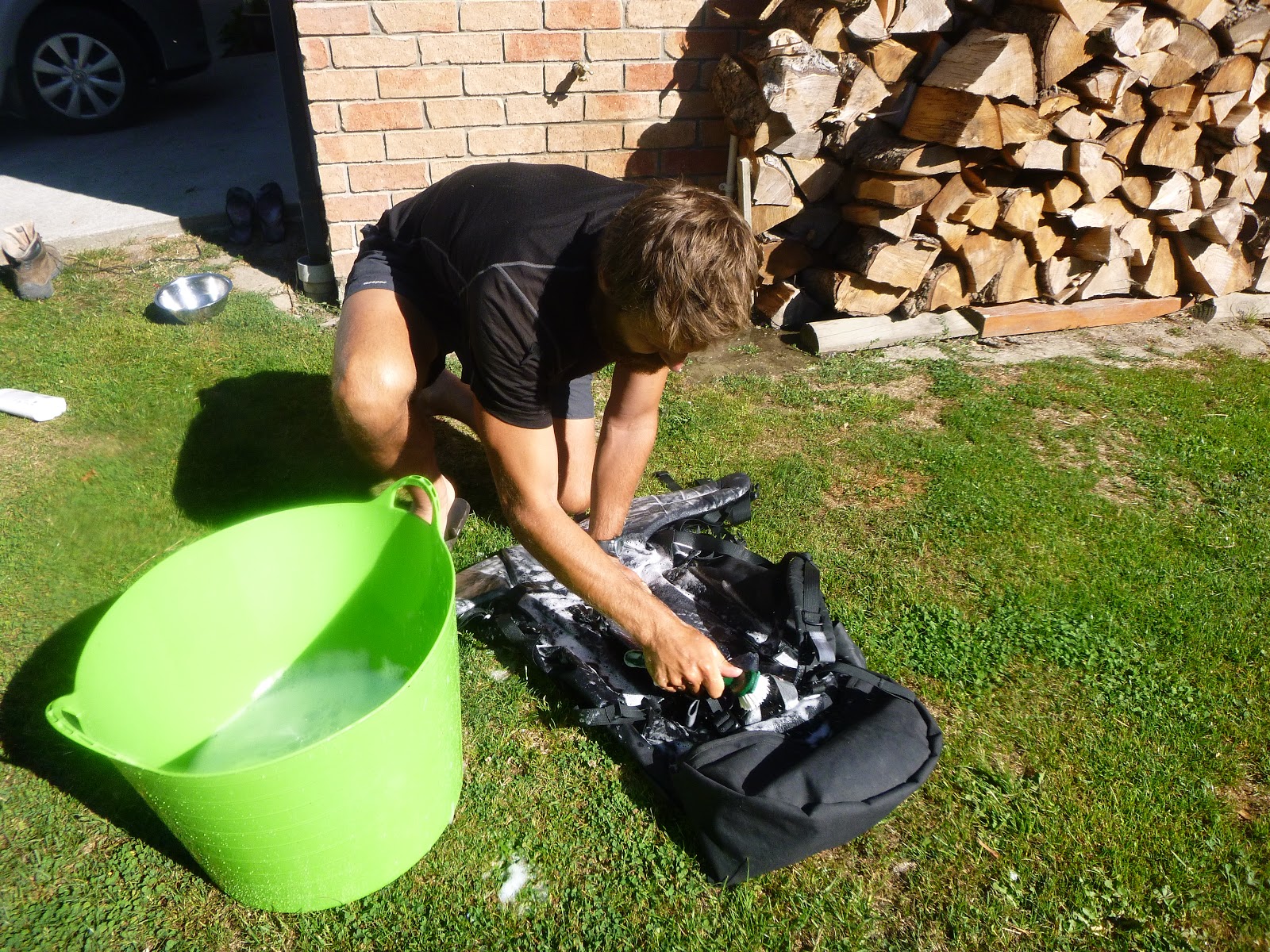
Scrubbing our packs clean from the built up sweat and bacteria.


2 years ago, Christchurch suffered a devistating earthquake,
killing over 180 people. The signs are still very present, with so
much more clean up work to be done.
What a reminder that life can be taken from us at any moment...
A reminder to live life while we have it!


Parts of the city still look like a war zone...
My memories of a picturesque garden city seem so distant, and
my heart goes out to the people of Christchurch.


Carol took us back to the trail head...Thanks Mum!!


From here, it will take 3 days to get to Lake Coleridge, then another 6 days
to the beautiful turquoise Lake Tekapo.
Find Lake Tekapo on the map...We will have completed approx 2,300 km's 
by then. Along this section, we will also get our first glimpse of New Zealand's
highest peak, Mount Cook, (named after the explorer Captain Cook).

Until then...eat well, love well and walk a lot!