Thursday, 4 April 2013

The Long Pathway Completed.


Upper east end of Lake Wakatipu with less than 2 weeks to go.


Take a big pan for these mushrooms!


 Along the Greenstone River


Sheep farms are predominant in Southland

The old phone booths of bygone days.


Moss covered rock


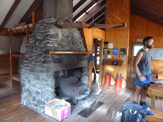
Martin's Hut, the last hut on the trail.
Martin’s Hut was built in 1905 by Fred Mason, to house a water race maintenance worker. Racemen were employed by mining companies to maintain the race, and to ensure a steady supply of water for mining operations. These men often lived by themselves in isolated environments. They faced an ongoing battle to clear fallen trees and branches, and to repair flood damage. Martin’s Hut is one of three gold mining era huts remaining on public conservation land in Southland.


The excitement of finishing is building...as we have
22 km's to go along highway 1, then just another 7 km's via trail, around to
Stirling Point. (Southern terminus)

5 more km's to Stirling Point.


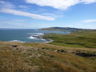
 Views of Stewart Island to the south and....count them....2 km's to go!


Stirling Point at Bluff and no where to go!
All done and dusted! We've made it!!
 3,054 km's (2,030 miles)
118 days to complete.


Awesome to have Beni join us. He walked the final 2 km's with us.
The operation on his knee, (torn cartilage), was successful.
His support from start to finish was priceless.


Now that we have hung our boots up for the last time on this trip, it is now time to reflect…

First, I want to thank all those who encouraged and helped us, before and during the journey.

A special thanks to:
Sue Eisaguirre, and everyone involved with Nature Track in California. A special, (and much needed), foundation, run by special people.
Kathy Gibson, and all those involved with New Zealand Special Olympics.

Walking for causes larger than ourselves kept us going when our minds and bodies wanted to stop.

My very supportive family and friends in NZ and in the USA, (always good to hear mum’s voice on the phone)…thanks Dad and brother Beni, for meeting up with us here and there…and thanks to my other brother, Joe, for your moral support on the phone from Australia.
Thanks also to Sarn’s mum, Carol, for flying over from Australia and making sure we were fed well.

Most of all, to my wife Melody, who gave me two thumbs up the moment I mentioned doing this journey. Getting encouragement like that was the deciding factor. Your support and encouragement throughout was invaluable!

We met a lot of friendly and hospitable people, which always renews ones faith in mankind.
They shared their hearts and homes with us smelly, scruffy hikers.
We also met other adventurers from different parts of the globe tackling the trail. We wish them success.

The scenery and countryside of New Zealand is varied and picturesque! The North Island…with gorgeous coastlines and it’s rolling to rugged farmlands.
The South Island…was more dramatic and physically challenging….fewer people and more open spaces.

The Te Araroa Trail, is by far, the most physically challenging I have experienced.
There were some easy sections…but for the most part…a tough workout.
I lost 14 lbs. of body weight...my muscles shrunk over time, and now I have to get a whole new wardrobe.

I am reminded that, there is a time and place for everything.  A time and a place to go, where you can reflect on life, and be inspired by the natural environment.

OK--------what next?

Tuesday, 2 April 2013

GEAR USED ON THE TE ARAROA TRAIL HIKE

The following gear is what I ended up using for most of the hike.
Some things I replaced or sent home.
It may look like a lot, but everything weighed in at approximately 13 kg's, (28.6 lbs).
The weight changed from 13 to 21 kg's, (28.6 to 46 lbs), when adding water
and food.


When preparing for a long hike and carrying a pack, choose good solid footwear
to suit the terrain. I chose these Vasque Bitterroots.
They gave me a good solid foundation, with ample ankle support.

I wore these Vasque Trail Runners during sections of road walking.


Light weight Crocs for camp shoes.

Top of picture: A thin mat, for extra protection on the tent floor from sharp sticks, etc...
Top left: This bag contains an Exped Air Mattress. Top right: A down jacket that doubles as a pillow.
Bottom left:  A Tarp Tent (weight is less than 1 kg, (2 lbs). Bottom right: sleeping bag with silk liner.
Far right: Hiking poles.

Here you see all the bedding/tent etc... layed out.

From top left to right: rain coat, Marino wool singlet, shorts, water proof over pants,
long sleeve fleece top, sleeveless top, shorts, long johns,
warm gloves, woollen hat, billed cap, 4 pairs of socks, gators,
knee brace, bug net, under wear, rain cover for back pack, micro fiber towel.
( missing is a long sleeve marino top)

Top left to right: foam pad for seat, water proof pack liner, bag with extra laces, twine etc,
bag with first aid stuff, water bottle, camera case, accessory bag, note pad,
2 litre water bladder, sunglasses, reading glasses, spare batteries etc, food storage bag,
toilet bag, head lamp and toilet paper 


Eating bowl with cup and utensils.


All the gear layed out except the food and water.

Next blog will feature the last 2 weeks of the hike.

Monday, 25 March 2013

Nearly done.

Hi everyone. Sending this from the small coastal town of Riverton on the south coast of New Zealand.
Just 60 km's (Approx 37 miles) to go and just 2 more days of walking and we will be
standing at Bluff. The southern terminus of the Te Araroa Trail.

Within a few days of arriving back with family, I will post 2 full blogs.
One of the gear we used and one to finalize the entire journey with some pics.

The weather forecast for the next few days is looking great.
The excitement of finishing is growing with every step, as is the anticipation
of completing an incredible journey.

See you in a few days.


Along the south coast heading toward Riverton


Sunset on the Riverton Harbor

Friday, 22 March 2013

The Southern Alps

The Southern Alps of New Zealand are the longest and highest mountain range in the country.  They consist of fairly new ranges in comparison to other ranges worldwide, and extend most of the length of the South Island.  As you have seen in some of the pictures I have already posted, you will find ice-blue glaciers, ancient forests, volcanic lakes, greenstone rivers and wide valleys...all which make up an amazing area of natural beauty! Check out two of my favorite areas below:

                   Mount Cook


Aoraki / Mount Cook is the highest mountain in New Zealand, reaching 3,754 metres (12,316 ft). It  consists of three summits, with the high peak spanning a mile long.   It lies in the Southern Alps, which is the mountain range that runs the length of the South Island.  Mount Cook National Park, was established in 1953, and contains more than 140 peaks standing over 2,000 metres (6,600 ft) and 72 named glaciers, which cover 40 percent of the park's 700 square kilometres (170,000 acres). It is a very popular distination for climbers and hikers, as the park offers a good challenge...but, you can enjoy it as a regular tourist with more than fantastics views and easy day walks, as Mount Cook Village is easy to get around.


                           The Remarkables


The Remarkables, located in Otago, are clearly visible from the nearby town of Queenstown.   Located on the southeastern shore of Lake Wakatipu, the range lives up to its name by rising sharply to create an impressive backdrop for the waters.  The area offers a wide range of activities to choose from in all seasons!

We are now just days away from Bluff, the official end of the Te Araroa Trail!  What an incredible journey it has been.  I'm very excited to get back home to Melody and family...and of course, the trail food will be happily tucked away for while!

I will be posting another blog once we have finished...until then...enjoy!

Friday, 15 March 2013

Lake Tekapo to Lake Wanaka (Lake district)

This summer has turned out to be a dandy for tramping...but certainly not for farming.
It has been one of the hottest and extremely dry seasons in a long time...however, it's been great for our hiking and the photos we have captured.

Lake Pukaki with Mount Cook in background.


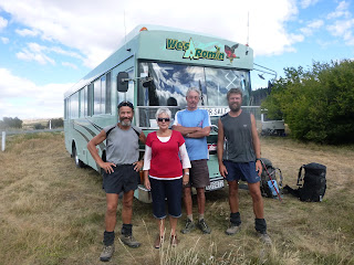
Gary and Madeline invited us into their motor home
for cold refreshments. Check out the name on the bus...
We didn't smell that bad on this day.

Lake Ohau

Taking a mid day nap high in the moutain's and dreaming
of Bluff...only about 450 km's...just a stones throw away...maybe not...

Big river valleys...they look like they go on forever don't they...almost do!

Steep...open.. and above tree line.

Overlooking Lake Hawea

Met these sky divers on the way down to Lake Hawea.
Malachi (middle) invited us to his home for a shower
and a cold beer. Malachi is a professional sky diver in Wanaka.
Salt of the earth friendly guy.

Heading around Lake Hawea.

On the shores of picturesque Lake Wanaka.

Becks and Chris (owners of Wanakayaks) hosted us at their place.
Just awesome friendly down to earth couple!


I haven't weighed myself in a while...
Last time, I was down to 141 lbs. (starting weight was 152 lbs)
Surely I can't loose any more...

Time will tell....

Question:  Do you know why the lakes and rivers can be so bright and vivid in color?

Lake Wanaka to Queenstown

Another beautiful but strenuous section of trail, through the Matitapu Range.

Morning sun becons us on...

What goes up, must come down!

4 km's through the stream...soggy feet!

Wow! look at this crystal clear water and how it reflects the colorful rocks.
"There's gold in them hills!"


Just north of Queenstown is the Millbrook Resort.

Queenstown is know as the "Adrenaline Capital" of the world!
For us, it represents 2,670 km's done and approx 2 weeks to go!

I will try and post at least once more before we make it to Bluff.
The excitement is building and becoming more palatable each day.
Too many thoughts going through my head right now...

Thursday, 7 March 2013

Arturs Pass to Lake Tekapo

The view looking back towards Arthur's Pass.


Long stretches

Big open valleys

"Shadow and Country Mouse" from Bishop, CA...they hiked the Appalachian Trail
in 2011, and are the first North bounders on the Te Araroa.

Hamilton Hut


Huge scree field

Crossing the Rangatata River. The river valley was over 5 miles wide and
took us two and a half hours to cross!

View of Lake Tekapo from Stag Saddle


First glimpse of Mount Cook in the back ground...Fantastic!!!

Above Lake Tekapo

Swanny putting on a great BBQ for us in Tekapo...Great host.
Sarn's friend from the Police Search and Rescue.

Sooo relaxing... in the hot pools of  Tekapo Springs.
If you are ever in this area, it is a must!
The only reason I left? - - - - - - - I was...can you guess...hungry!

Next big town is Queenstown.  About 200 km's from here.
The adrenalin capital of the world.

See you there!